CommoFreq
Member
When SHTF, just think of various episodes of Walking Dead, when a team would go out to do whatever, while everyone who stayed behind, nervously chewed their fingernails, waiting and wondering. Time and time again, I thought, "They need some APRS". What exactly is it?
Well, for starters, it's not new technology. Hams have been playing with this for years, successfully, while constantly making improvements. This has been a work in progress, well, since I'd say around 1998 (the first time I personally saw it), so today, it's reached perfection. All it does is take your GPS location, and send it out on your radio, at certain intervals. Simple enough?
On the receiving end, a radio is interfaced with a computer, and your information is displayed on a map, so that others can see where you are. That way, if anything were to happen to you, someone could come straight there to help. So. Let's take a deeper look into how this works.
Mobile Station
For your mobile station, you will need a GPS, a way to interface it to your radio, and, your radio. Since your radio will be dedicated to this task only, you'll want to use a separate radio just for this. For that reason, a lot of people prefer to use handhelds for APRS. They're small, and, the APRS even has an entire repeater system out there, dedicated to repeating APRS signals!
Here is a typical mobile setup:
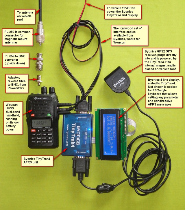
(Note: The Byonics 4-line display is something extra - not necessary. All it does is display the information being sent.)
How it works:
1. The GPS will send the coordinates, direction, speed, and elevation to the interface.
2. The interface will take this information, and pair it with other information that you've saved, such as the icon that you would like to pop up to represent you on a map, a callsign, and any comments that you want to include. Once all of this info is bundled, it will key your radio and send this information as AUDIO into the microphone jack, every so often (you actually set this up - standard is 1 min intervals).
That's it! Now, this opens the door to a LOT of possibilities. Here are a few things to know:
1. The agreed-upon APRS frequency is 144.390 in the US, and that's simplex. In other words, if you are using any other frequency, you will not have the assistance of the APRS repeater network. If you use this frequency, you will of course, see everyone else in your area who is doing this, on your map.
2. When SHTF, you probably don't want to advertise your location to the general public anyway. Since the digital information is being sent as AUDIO, you can use any radio you wish (even CB radio, with a little wiring), on any frequency you wish. Just make sure, of course, that your base station is also on the same frequency.
Base Station
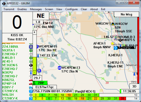
For your base station, all you will need is a computer and a radio (or even a scanner will work for this too). For your mapping program, you will be using APRSISCE 32. You can download it here. Go ahead and install it as well, and then run it. Now, it will ask you for a password if you wish to transmit your base station location. You definitely don't want to do that anyway, so don't worry about it. It will still receive everything and show it on the map.
1. Next, you will want to connect a headphone cable (2.5mm jack, male on both ends) from your radio or scanner, to the microphone input on your computer.
2. Set it (for testing purposes) to 144.390 FM, the universal APRS frequency.
3. Disconnect from the internet.
We do step 3, because this mapping program will also use the internet to get the location of people out there. We are doing this for a SHTF scenario, which means there won't be any internet, and because we want to make sure that ALL of the information is coming exclusively from your radio / scanner.
Slowly, but surely, you will hear short bursts of "squawking data" and see stations/call signs pop-up in the left-hand column. Not all of them are travelling. Some are just weather stations reporting weather info the same way you are reporting location info. Anyway, if you have made it this far, you are pretty much set. You can click on any of them on the map to get more information, or even set the map to track them.
Of course, as I said, once you come off of 144.39, you lose them. If you want to set this up just for you and "your people", then you'll probably want to use a secret frequency.
***An item to note here is the mapping program itself. As as default, it uses OpenStreetMap tiles, which load as you browse around and zoom in and out. You'll see it download the tiles when a green ring ripples from the center of the map, outward. They are stored on your computer forever, and so, with an internet outage, you can still use the map. However, the regions / zoom levels that you've never looked at, will be unavailable during an internet outage. So, once you download this and get it setup and working, you'll want to scroll around your area thoroughly at all zoom levels, to get those maps saved.
And that's pretty much the jist of it. Questions and comments welcome. If you need help getting yours set-up, I'm here to help.
Well, for starters, it's not new technology. Hams have been playing with this for years, successfully, while constantly making improvements. This has been a work in progress, well, since I'd say around 1998 (the first time I personally saw it), so today, it's reached perfection. All it does is take your GPS location, and send it out on your radio, at certain intervals. Simple enough?
On the receiving end, a radio is interfaced with a computer, and your information is displayed on a map, so that others can see where you are. That way, if anything were to happen to you, someone could come straight there to help. So. Let's take a deeper look into how this works.
Mobile Station
For your mobile station, you will need a GPS, a way to interface it to your radio, and, your radio. Since your radio will be dedicated to this task only, you'll want to use a separate radio just for this. For that reason, a lot of people prefer to use handhelds for APRS. They're small, and, the APRS even has an entire repeater system out there, dedicated to repeating APRS signals!
Here is a typical mobile setup:
(Note: The Byonics 4-line display is something extra - not necessary. All it does is display the information being sent.)
How it works:
1. The GPS will send the coordinates, direction, speed, and elevation to the interface.
2. The interface will take this information, and pair it with other information that you've saved, such as the icon that you would like to pop up to represent you on a map, a callsign, and any comments that you want to include. Once all of this info is bundled, it will key your radio and send this information as AUDIO into the microphone jack, every so often (you actually set this up - standard is 1 min intervals).
That's it! Now, this opens the door to a LOT of possibilities. Here are a few things to know:
1. The agreed-upon APRS frequency is 144.390 in the US, and that's simplex. In other words, if you are using any other frequency, you will not have the assistance of the APRS repeater network. If you use this frequency, you will of course, see everyone else in your area who is doing this, on your map.
2. When SHTF, you probably don't want to advertise your location to the general public anyway. Since the digital information is being sent as AUDIO, you can use any radio you wish (even CB radio, with a little wiring), on any frequency you wish. Just make sure, of course, that your base station is also on the same frequency.
Base Station
For your base station, all you will need is a computer and a radio (or even a scanner will work for this too). For your mapping program, you will be using APRSISCE 32. You can download it here. Go ahead and install it as well, and then run it. Now, it will ask you for a password if you wish to transmit your base station location. You definitely don't want to do that anyway, so don't worry about it. It will still receive everything and show it on the map.
1. Next, you will want to connect a headphone cable (2.5mm jack, male on both ends) from your radio or scanner, to the microphone input on your computer.
2. Set it (for testing purposes) to 144.390 FM, the universal APRS frequency.
3. Disconnect from the internet.
We do step 3, because this mapping program will also use the internet to get the location of people out there. We are doing this for a SHTF scenario, which means there won't be any internet, and because we want to make sure that ALL of the information is coming exclusively from your radio / scanner.
Slowly, but surely, you will hear short bursts of "squawking data" and see stations/call signs pop-up in the left-hand column. Not all of them are travelling. Some are just weather stations reporting weather info the same way you are reporting location info. Anyway, if you have made it this far, you are pretty much set. You can click on any of them on the map to get more information, or even set the map to track them.
Of course, as I said, once you come off of 144.39, you lose them. If you want to set this up just for you and "your people", then you'll probably want to use a secret frequency.
***An item to note here is the mapping program itself. As as default, it uses OpenStreetMap tiles, which load as you browse around and zoom in and out. You'll see it download the tiles when a green ring ripples from the center of the map, outward. They are stored on your computer forever, and so, with an internet outage, you can still use the map. However, the regions / zoom levels that you've never looked at, will be unavailable during an internet outage. So, once you download this and get it setup and working, you'll want to scroll around your area thoroughly at all zoom levels, to get those maps saved.
And that's pretty much the jist of it. Questions and comments welcome. If you need help getting yours set-up, I'm here to help.
")