CommoFreq
Member
So, I have a habit of disappearing and then reappearing months later, with a new write-up. This time, we'll be discussing APRS, and why from a doomsday perspective, it receives mixed reactions for SHTF use. But before we can get into that, let's first take a look at what APRS is, and what it does.
What It Is
It has a few different uses, but primarily, it's a GPS tracking system that sends your coordinates over a radio (standard is once every 3 minutes). On the other end, another radio receives the data and shows your location on a mapping program on a computer. The beauty about this is, if your computer has an internal microphone (a typical laptop, basically), then there are no connections that need to be made! Just sit your radio next to the computer, and the computer will "listen" to the audio output of your radio, receive the data, and plot it!
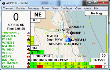
(APRSIS32 is the most common APRS program in use.)
Assuming that the GPS satellites aren't knocked out of the sky during a doomsday scenario, then you will have the ability to go out and forage for food and supplies, shoot starving libtard zombies, blow bridges or whatever you fancy, while someone back at base can monitor your location. That way if you get into any trouble, all you have to do is cry for help, and help will know exactly where you are!
Equipment Needed:
Full Setup:
1 computer (preferably a laptop)
2 radios (Baofeng hand-helds are popular for APRS use)
1 APRS module (TinyTrak4 is the go-to solution)
1 GPS antenna (Normally comes with the TinyTrak in a package)
Download APRSIS32
Download DireWolf
Receive Only:
1 computer (preferably a laptop)
1 radio capable of listening on 144.39MHz (2 meters)
Download APRSIS32
Download DireWolf
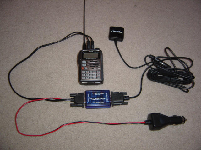
(It's a fairly simple setup: The radio and GPS antenna plug into the TinyTrak, which plugs into a
12v lighter socket. This only powers the TinyTrak and GPS antenna - NOT the radio too!)
How APRS Works Today & How it Works Doomsday
Today, APRS is pretty much found only in the ham radio world (which is why I've posted this here). If you tune into 144.390 FM (in North America - otherwise look up the freq for your area), you'll hear the data bursts being sent out, around the clock. APRS has been around in common use since the '90s, but over the years, it has evolved to the point where listening stations automatically report the received location data onto the internet (happens in the background of APRSIS32).
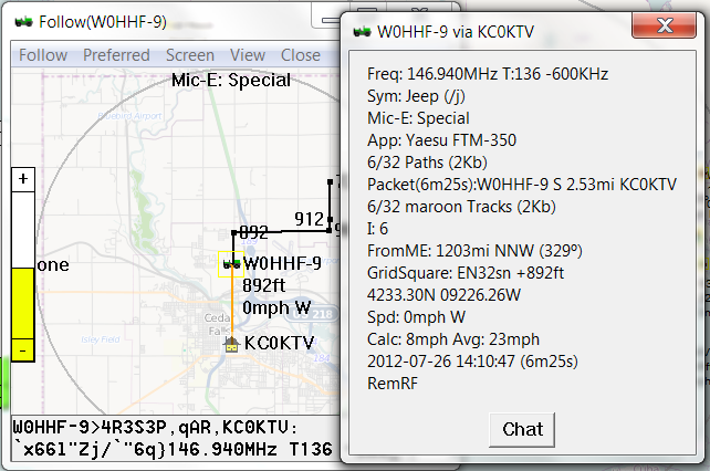
You can get speed, direction, distance from the sending station, all kinds of info . . .
Also, "digipeaters" which hear your location info will take it, and send it back out again, as a normal repeater would. The only difference is, they are not duplexing. They are "parroting" your signal out on the same freq. You can get hundreds of miles away from base, and they will still see where you are. All thanks to digipeaters.
Remember when I said that APRS has a few different uses? Well, a few of us dorks have actually interfaced these TinyTrak devices with home weather stations. And instead of sending just location info, they are sending the weather data that the station has collected. Many of these are not at homes, but rather connected to solar panels and put out in the wilderness, to operate autonomously. So with APRSIS32, during doomsday, you might even be able to get some weather info. Every area will have around 3 of these close by at minimum.
But that's APRS today. . .
In reality, these are all unwritten rules. You could theoretically hook this up to a CB radio, or FRS for that matter. It's just that we all kind of agreed to use 144.39 out of cooperation. That's how you can get your signal digipeated. During doomsday, you probably won't want to advertise your location that way. Which means, you'll want to be using a different frequency. Something hidden. Harder to find. Lesser expected.
So, here are some of the concerns that the "naysayers" will be sure to point out:
1. "If there's no GPS, there's no APRS". And that's true. If the GPS satellites get nuked, then this is pretty much all for nothing (except the weather stations). Oh well. It's a tool to use until it's no longer usable - just like every other doomsday preparation.
2. "You are advertising your position". Well, if you're still using the APRS frequency on 144.39, then yes, I would call that "advertising". If you're tucked away off of a ham band but close enough to it so that your antenna still works, then it shouldn't be a problem. Even most hams aren't familiar with APRS. And when SHTF, it's not like you can just go and download a copy of APRSIS32 and figure it out. If you don't already have it, you missed the train on that deal.
A couple of other things you should probably know:
- Getting this all setup at first, can be a real bitch. The good news is, once it's done, it's done. And it's well worth the work.
- Some ham radios nowadays actually come with APRS and a GPS antenna built-in. Icom D-STAR radios (like the IC-5100) have what's called DPRS - same thing, but different signal type. A copy of DireWolf will automatically decode those and send to the mapping program. You need DireWolf anyway - it runs in tandem with APRSIS32.
If you guys have any questions, you know the deal - post them below!
What It Is
It has a few different uses, but primarily, it's a GPS tracking system that sends your coordinates over a radio (standard is once every 3 minutes). On the other end, another radio receives the data and shows your location on a mapping program on a computer. The beauty about this is, if your computer has an internal microphone (a typical laptop, basically), then there are no connections that need to be made! Just sit your radio next to the computer, and the computer will "listen" to the audio output of your radio, receive the data, and plot it!
(APRSIS32 is the most common APRS program in use.)
Assuming that the GPS satellites aren't knocked out of the sky during a doomsday scenario, then you will have the ability to go out and forage for food and supplies, shoot starving libtard zombies, blow bridges or whatever you fancy, while someone back at base can monitor your location. That way if you get into any trouble, all you have to do is cry for help, and help will know exactly where you are!
Equipment Needed:
Full Setup:
1 computer (preferably a laptop)
2 radios (Baofeng hand-helds are popular for APRS use)
1 APRS module (TinyTrak4 is the go-to solution)
1 GPS antenna (Normally comes with the TinyTrak in a package)
Download APRSIS32
Download DireWolf
Receive Only:
1 computer (preferably a laptop)
1 radio capable of listening on 144.39MHz (2 meters)
Download APRSIS32
Download DireWolf
(It's a fairly simple setup: The radio and GPS antenna plug into the TinyTrak, which plugs into a
12v lighter socket. This only powers the TinyTrak and GPS antenna - NOT the radio too!)
How APRS Works Today & How it Works Doomsday
Today, APRS is pretty much found only in the ham radio world (which is why I've posted this here). If you tune into 144.390 FM (in North America - otherwise look up the freq for your area), you'll hear the data bursts being sent out, around the clock. APRS has been around in common use since the '90s, but over the years, it has evolved to the point where listening stations automatically report the received location data onto the internet (happens in the background of APRSIS32).
You can get speed, direction, distance from the sending station, all kinds of info . . .
Also, "digipeaters" which hear your location info will take it, and send it back out again, as a normal repeater would. The only difference is, they are not duplexing. They are "parroting" your signal out on the same freq. You can get hundreds of miles away from base, and they will still see where you are. All thanks to digipeaters.
Remember when I said that APRS has a few different uses? Well, a few of us dorks have actually interfaced these TinyTrak devices with home weather stations. And instead of sending just location info, they are sending the weather data that the station has collected. Many of these are not at homes, but rather connected to solar panels and put out in the wilderness, to operate autonomously. So with APRSIS32, during doomsday, you might even be able to get some weather info. Every area will have around 3 of these close by at minimum.
But that's APRS today. . .
In reality, these are all unwritten rules. You could theoretically hook this up to a CB radio, or FRS for that matter. It's just that we all kind of agreed to use 144.39 out of cooperation. That's how you can get your signal digipeated. During doomsday, you probably won't want to advertise your location that way. Which means, you'll want to be using a different frequency. Something hidden. Harder to find. Lesser expected.
So, here are some of the concerns that the "naysayers" will be sure to point out:
1. "If there's no GPS, there's no APRS". And that's true. If the GPS satellites get nuked, then this is pretty much all for nothing (except the weather stations). Oh well. It's a tool to use until it's no longer usable - just like every other doomsday preparation.
2. "You are advertising your position". Well, if you're still using the APRS frequency on 144.39, then yes, I would call that "advertising". If you're tucked away off of a ham band but close enough to it so that your antenna still works, then it shouldn't be a problem. Even most hams aren't familiar with APRS. And when SHTF, it's not like you can just go and download a copy of APRSIS32 and figure it out. If you don't already have it, you missed the train on that deal.
A couple of other things you should probably know:
- Getting this all setup at first, can be a real bitch. The good news is, once it's done, it's done. And it's well worth the work.
- Some ham radios nowadays actually come with APRS and a GPS antenna built-in. Icom D-STAR radios (like the IC-5100) have what's called DPRS - same thing, but different signal type. A copy of DireWolf will automatically decode those and send to the mapping program. You need DireWolf anyway - it runs in tandem with APRSIS32.
If you guys have any questions, you know the deal - post them below!